
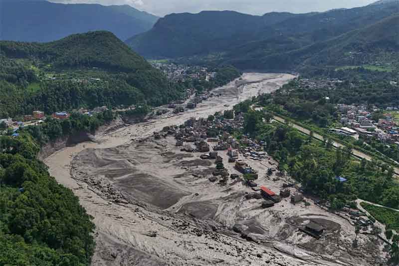
The catastrophic floods and debris flows that struck Nepal and Tibet on 26 August 2026 have once again demonstrated the extraordinary vulnerability of the Himalayan region. Entire settlements, roads, bridges and power infrastructure have been swept away. Hundreds of people have died and more than a thousand remain missing, while many thousands nore have been displaced. Rescue and relief operations are continuing amid the threat of further flooding from newly formed or blocked glacial lake.
My first response is of grief and solidarity. My deepest condolences go to the families who have lost loved ones and to all the people of Nepal whose homes, livelihoods and communities have been devastated.
But grief must also lead to reflection and action.
This catastrophe should not be viewed simply as another unfortunate “natural disaster”. The immediate physical trigger appears to have been a massive collapse of glacier, rock and ice near the north face of Langtang Lirung mountain, producing an enormous avalanche and debris flow that travelled down the Lhende Khola valley and into the downstream river system. Preliminary scientific assessments indicate that the collapse destabilised a huge volume of ice and rock, generating an exceptionally powerful flood and debris surge.
The precise sequence and contribution of individual factors will require further scientific investigation. But the larger context is increasingly clear : a rapidly warming Himalaya is becoming a more unstable Himalaya.
And climate change is interacting with another danger of our own making — increasingly inappropriate and poorly planned ‘developmen’ in some of the most fragile landscapes on Earth.
—-
A mountain system under unprecedented stress
The Himalaya is not merely a spectacular mountain range. It is one of Earth’s great cryospheric systems and the source region of some of Asia’s most important rivers.
A widely used satellite-based assessment estimated the glaciated area of the Himalaya at approximately 22,800 square kilometres, with another 18,000 square kilometres in the Karakoram — about 40,800 km² altogether. Estimates vary depending on the geographical boundaries and mapping methodology, but these figures provide a useful indication of the enormous scale of the region’s permanent ice reservoir.
This frozen landscape is changing rapidly.
The International Centre for Integrated Mountain Development (ICIMOD) reported in 2026 that glaciers across the Hindu Kush Himalaya are now losing ice at roughly twice the rate observed around the beginning of the 21st century. Its latest assessments indicate that glaciers have lost up to 27 metres of ice thickness since 1975 in some parts of the region.
The change is not simply that glaciers are getting shorter. Snowlines are shifting, ice is thinning, glacier tongues are retreating, permafrost is degrading, debris-covered ice is changing, and new meltwater lakes are appearing in formerly ice-covered terrain.
This is transforming the very physical geography of the mountains.
And that transformation is creating new hazards.
—
The dangerous birth and expansion of glacial lakes
As glaciers retreat, they often leave depressions behind. Meltwater accumulates in these depressions, frequently behind unstable ridges of glacial debris called moraines. These become glacial lakes.
A growing lake is not automatically dangerous. But some lakes can become highly hazardous when they are impounded by unstable moraine dams or ice, or when they lie below steep slopes and hanging glaciers capable of generating avalanches.
An avalanche falling into a lake can produce a displacement wave large enough to overtop the moraine. The moraine may then breach, releasing millions of cubic metres of water in minutes.
This is a Glacial Lake Outburst Flood—or GLOF.
And the problem is growing.
Research has documented the formation of new glacial lakes and the expansion of existing ones across the Himalaya as glaciers retreat. ICIMOD’s inventory of the Hindu Kush Himalayan region identified dozens of potentially dangerous glacial lakes requiring close monitoring.
In India’s Himalayan region, government agencies have now identified 189 high-risk glacial lakes, including 56 classified as “very high risk”, requiring focused monitoring and mitigation. More broadly, the Central Water Commission has been monitoring thousands of glacial lakes across the Himalayan river basins.
These are not merely numbers on a database. Each lake represents a potential interaction between a changing glacier, unstable mountain terrain and people and infrastructure downstream.
—
South Lhonak : A warning that became a disaster
The tragedy of South Lhonak Lake in Sikkim on 3–4 October 2023 is one of the clearest recent warnings.
South Lhonak had been expanding rapidly as the surrounding glacier retreated. Research subsequently estimated that the lake expanded from approximately 1.12 km² in 2016 to 1.63 km² in 2023—a roughly 45% increase.
An ice-rock avalanche entered the lake, generating a surge wave that overtopped and breached the moraine dam. The resulting GLOF travelled downstream through the Teesta valley, destroying infrastructure and severely damaging the Chungthang hydropower project.
Importantly, scientists had studied the lake’s potential GLOF hazard before the disaster occurred. Modelling had already demonstrated that avalanche-generated waves could overtop the moraine and threaten infrastructure downstream.
The lesson is profound:
The question is no longer whether such events can happen. The question is whether we identify the danger early enough—and whether governments are willing to act on that knowledge.
—
Chamoli 2021 : another kind of cryospheric catastrophe
The February 2021 disaster in Chamoli, Uttarakhand, provides another crucial warning, although it should not technically be described as a GLOF.
On 7 February 2021, approximately 27 million cubic metres of rock and glacier ice collapsed from the steep north face of Ronti Peak. The resulting rock-and-ice avalanche transformed into a highly mobile debris flow that travelled through the Ronti Gad, Rishiganga and Dhauliganga valleys. More than 200 people were killed or remained missing, and two hydropower projects were severely damaged.
The disaster demonstrated something equally important : the Himalaya does not need a glacial lake to generate a catastrophic flood.
A warming mountain system can produce compound chains of hazards:
warming → glacier/ice destabilisation → rock or ice avalanche → debris flow → river blockage → sudden flood → destruction downstream.
Add extreme rainfall, landslides or another avalanche to that chain, and the consequences can become even more severe.
—
The warming is happening faster in the high mountains
The physical changes in Himalayan ice cannot be separated from the region’s changing climate.
Long-term research indicates that the Hindu Kush Himalaya has warmed substantially over the last century. A major assessment found decadal mean surface-air temperature warming of well over 0.1°C per decade during 1901–2014, accelerating to approximately 0.2°C per decade during 1951–2014.
At elevations above 4,000 metres, warming has been considerably stronger in some locations, reaching approximately 0.5°C per decade. This phenomenon is commonly referred to as elevation-dependent warming.
Observational research specifically examining the glaciated parts of the Indian Himalaya found substantial long-term warming between 1901 and 2016. The eastern Himalaya showed approximately 0.93°C of warming, the central Himalaya about 0.73°C, and the western Himalaya about 0.64°C over the study period. Winter warming was particularly strong.
More recent research continues to identify strong warming at high elevations.
This is not simply an extrapolation from climate models. Meteorological observations, satellite measurements and reanalysis datasets are all showing a changing Himalayan climate.
A long-term analysis of temperature observations from 49 stations in Nepal found substantially greater warming in the Middle Mountains and Himalayan regions than in the lower Siwalik and Terai regions. In much of the Himalayan and Middle Mountain region, maximum-temperature trends after 1977 were approximately 0.06–0.12°C per year in the study period, compared with less than 0.03°C per year in the southern lowlands.
Indian research likewise shows pronounced regional differences. A recent assessment using observations and reanalysis data found warming rates of around 0.2–0.5°C per decade during the post-monsoon season in the western Himalaya, compared with much weaker warming in some parts of peninsular India.
Thus, it is reasonable to say that many parts of the Himalaya are warming faster than large areas of India’s peninsula, although the precise difference varies by elevation, season, location and observational period.
—
The albedo feedback: when melting ice makes warming worse
There is another, less visible process that makes the situation even more dangerous.
It is called the snow-and-ice albedo feedback.
Fresh snow and clean ice are extremely reflective. They send a large proportion of incoming sunlight back into space.
Dark rock, soil, vegetation, debris and especially open water absorb much more solar energy.
As snow and ice disappear, the Himalaya therefore becomes darker.
The sequence becomes:
warming → snow and ice melt → darker surfaces exposed → more solar energy absorbed → additional warming → more melting.
This is a classic positive feedback loop.
Satellite observations have documented declining albedo across Himalayan glaciers. Research using MODIS observations for 2000–2011 found that Himalayan, Karakoram and Hindu Kush glaciers had generally been darkening, with particularly rapid decreases in albedo at elevations above 6,000 metres.
A 2024 study of the central Himalaya found that reductions in snow and ice cover and the expansion of water bodies were producing lower surface albedo and thereby amplifying local warming and glacier melt. The effect became particularly pronounced at elevations above approximately 4,500 metres.
Another major modelling study concluded that snow/ice albedo feedback contributed approximately 2.6°C of warming in the Himalaya in its attribution analysis and was the largest contributor among the feedback processes examined.
This does not mean that the entire Himalaya has literally warmed by an additional 2.6°C solely because of albedo. Rather, it demonstrates how powerful the regional feedback can be in amplifying externally forced warming.
The loss of the white Himalayan surface is therefore not merely a symptom of warming.
It can become an amplifier of warming.
—
Black carbon and dust add another layer of danger
The albedo problem is also affected by air pollution.
Black carbon and other light-absorbing particles can settle on snow and ice, darkening the surface and increasing solar absorption.
Modelling studies indicate that aerosol-induced snow darkening can substantially accelerate Himalayan snowmelt. One study estimated that aerosol-induced reduction in snow albedo could increase near-surface air temperature by approximately 1.47°C during spring, reduce snow cover by about 10.6%, and increase accumulated snowmelt substantially.
This creates another feedback:
air pollution → darker snow → greater solar absorption → faster snowmelt → darker ground/water exposed → further warming.
The Himalayan climate crisis is therefore simultaneously a greenhouse-gas problem, a cryosphere problem and, in some areas, an air-pollution problem.
—
Climate change meets unsafe development
But climate change alone does not explain why a mountain hazard becomes a humanitarian catastrophe.
A glacier can collapse in an uninhabited valley and produce enormous physical destruction without causing a major human disaster.
The disaster occurs when the hazard intersects with people, settlements and infrastructure.
This is where Himalayan development policies urgently need reconsideration.
Across the region, roads are being cut into unstable slopes. Hydropower projects are proliferating along narrow river valleys. Towns and settlements are expanding into floodplains and debris-flow corridors. Construction is sometimes taking place without adequately accounting for cascading hazards that may originate tens of kilometres upstream.
The Chamoli disaster made this intersection between natural hazards and infrastructure painfully clear. The scientific investigation explicitly highlighted the importance of sustainable development and adequate monitoring in high-mountain environments.
The same principle applies to GLOFs.
A glacial lake thousands of metres above sea level may seem remote and irrelevant to a town below. But a flood released from that lake can travel tens of kilometres downstream, carrying enormous quantities of water, ice, boulders and sediment.
The danger therefore needs to be mapped from the lake to the valley floor—not merely around the lake itself.
—
The Himalaya needs a transboundary early-warning system
The Himalaya does not respect political boundaries.
A glacier may be located in China, a lake may drain towards Nepal or India, and the resulting flood may travel hundreds of kilometres downstream through another country.
The recent Nepal disaster is an extraordinary illustration of this interconnectedness. The collapse occurred in the high mountains near the Nepal–China border, but the resulting debris flow affected settlements and infrastructure far downstream.
Therefore, disaster preparedness cannot remain confined within national borders.
India, Nepal, Bhutan, China and Pakistan—and the wider Himalayan countries—need a regional Himalayan Cryosphere Early-Warning and Risk Observatory.
Such a system should include:
1. Continuous satellite monitoring
High-resolution satellite imagery should continuously track:
– glacier retreat and thinning;
– snow cover;
– glacial lake growth;
– moraine stability;
– ice cliffs and hanging glaciers;
– landslide-prone slopes;
– newly formed lakes;
– river blockages.
2. Local real-time sensors
Satellite observations must be complemented by ground instruments:
– automatic weather stations;
– lake-level sensors;
– river gauges;
– seismic stations;
– cameras;
– GPS and ground-deformation monitoring;
– acoustic and radar systems where appropriate.
3. Community-level warning systems
A warning that reaches a government office but not a village in time is not an effective early-warning system.
Communities downstream of high-risk lakes and valleys need simple, redundant and locally understandable warning mechanisms—sirens, mobile alerts, radio communication and trained village disaster teams.
4. Shared data across borders
Real-time data concerning potentially dangerous lakes and mountain instability should not be treated as a national-security secret when the consequences of a failure could cross international boundaries.
The countries sharing the Himalayan river systems need mechanisms for rapid exchange of hydrological, meteorological, seismic and satellite information.
—
Map the danger—and move people and infrastructure out of it
Perhaps the most politically difficult but essential step is to identify infrastructure that should not be there.
Every major Himalayan valley should have hazard maps showing potential:
– GLOF inundation;
– debris-flow pathways;
– landslide runout;
– avalanche runout;
– flash-flood corridors;
– river-bank erosion;
– earthquake-triggered landslides.
These maps should then be overlaid with the location of:
– settlements;
– schools;
– hospitals;
– roads;
– bridges;
– hydropower plants;
– transmission lines;
– dams;
– tourism infrastructure.
Where existing infrastructure is located directly in catastrophic hazard corridors, governments should consider relocation, redesign or managed retreat.
And, critically, new high-risk infrastructure should not be approved simply because an engineering structure can theoretically withstand the hazard.
There are situations in which the scientifically safest engineering decision is not to build.
—
From disaster response to disaster prevention
For decades, Himalayan governments have often followed a familiar cycle:
disaster → rescue → compensation → reconstruction → rebuilding in the same vulnerable location → next disaster.
That cycle is becoming increasingly untenable.
The climate is changing faster than historical experience can guide us.
A road that survived for 50 years may not be safe for another 50. A glacial lake that appeared relatively stable for decades can change dramatically within a few years. A valley that never experienced a major flood in living memory may now face an entirely different hazard regime.
The appropriate response therefore cannot be simply “build stronger”.
It must be:
build less in dangerous places, monitor more, restore ecosystems, protect natural drainage and flood buffers, and relocate people and infrastructure where necessary.
—
The Himalaya is not a construction site
The Himalaya is one of the youngest and most geologically dynamic mountain systems on Earth. It is simultaneously a climate regulator, a water tower, a biodiversity reservoir and the home of millions of people.
Its landscapes cannot be treated as empty spaces waiting for roads, dams, tunnels, hotels and other infrastructure.
Development is necessary. Himalayan communities have every right to better roads, electricity, communications, healthcare, education and livelihoods.
But development must be compatible with the carrying capacity and geological realities of the mountains.
The choice should not be framed as “development versus no development”.
It should be:
safe and sustainable development versus reckless development.
—
A warning from the mountains
The Nepal catastrophe is not an isolated event.
It follows South Lhonak in Sikkim in 2023, Chamoli in 2021, Dharali in 2025 and numerous other Himalayan floods, landslides, avalanches and GLOFs across recent decades. Each event has different immediate causes. Some are triggered by extreme rainfall, some by avalanches, some by landslides, some by earthquakes and some by combinations of several processes.
But the background conditions are changing.
Glaciers are shrinking.
Snow and ice are disappearing.
Glacial lakes are expanding.
Permafrost is destabilising.
The high mountains are warming rapidly.
The white, reflective cryosphere is being replaced by darker rock, soil and water, creating additional heat absorption.
And human infrastructure is increasingly occupying the very valleys through which catastrophic flows naturally travel.
This is why the Nepal tragedy should become a turning point.
The countries of the Himalaya must urgently cooperate to establish real-time cryosphere monitoring, transboundary early-warning systems, comprehensive hazard mapping and climate-resilient development standards.
And where science shows that settlements or infrastructure lie directly in the path of potentially catastrophic floods or debris flows, governments must have the courage to relocate them.
The alternative is to continue rebuilding after every disaster—at ever greater human and financial cost.
The people of Nepal, and all Himalayan communities, deserve better.
The Himalaya is warning us. We must listen before the next warning becomes another and bigger catastrophe.